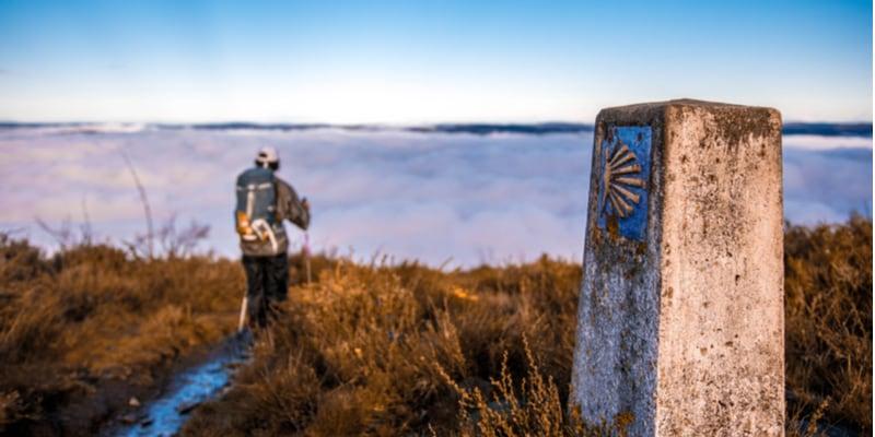
The English Way is one of the routes of the Pilgrim's Way to Santiago. It is a maritime route and is usually very popular with tourists from Scandinavian countries, the Netherlands and northern France.
In ancient times, pilgrims used to arrive on board small ships in northern Spain, on the coast of Galicia, especially in the ports of Ferrol and La Coruña, to cross this stretch and from there set off on foot to Santiago de Compostela.
There are records of this route as far back as the 12th century, when a crusading army headed for Lisbon to help the king fight the Arab invasion and stopped in Jerusalem to pay homage to the tomb of the Apostle.
The first written document referring to this path is instead due to an English monk Nicolas Bergsson who, between 1154 and 1159, traced the first route from Iceland to the Kiel Canal on the border of Denmark and Germany.
English Way to Santiago, stages map and advice
The English route to Santiago includes 6 stages to be covered in 6 days:
Day 1. Ferrol/ Neda - 15 km
Day 2. Neda / Pontedeume - 16 km
Day 3. Pontedeume / Betanzos - 21 km
Day 4 Betanzos / Bruma - 28.3 km
Day 5 Buruma/ Sigueiro - 24.8 km
Day 6 Sigueiro/ Santiago de Compostela - 16.5 km

The route starts from La Coruna or in most cases from Ferrol. The departure from Ferrol is preferred because the 'Compostela' (certificate of walking) is only issued by the Bishop of Santiago to those who walk at least 100 km or cycle 200 km.
La Coruña - Santiago, on the other hand, has a distance of less than 100 km and in that case - in order to obtain the 'Compostela' - pilgrims must prove that they have covered the missing distance in their countries of origin or by visiting the city's Jacobean areas and then arriving at the tomb of the Apostle.
1. Ferrol - Neda
We set off from the ancient port of As Curuxeiras.
The route is coastal and fairly easy and quiet. The start is marked by a stone monolith with the symbol of Galicia carved on it. Following the coastline, you arrive in Neda, a charming town with many churches and monuments to visit and famous for its bread, which has an ancient tradition. In Neda you can stay at the pilgrims' hostel or in other small establishments.
2. Neda- Pontedeume
This 16-kilometre stage is also fairly easy with a simple coastal route. Taking the Ria Ares path, one follows the coast along a route close to the main road and full of refreshment points where one can stop to rest and refresh oneself.
Once in Pontedeume, a fishing village, you can visit the many monuments and fortresses, palaces and churches, including the Romanesque churches of San Martin de Andrade and San Miguel de Breamo, as well as the Andrade Fortress.
3. Pontedeume - Betanzos
After a two-kilometre climb to leave Pontedeume, the remaining kilometres of this stage are covered almost entirely in the company of the sea. In fact, the rest of the route is a stroll through beautiful landscapes and beautiful beaches where you can stop.
Along this route there are many small towns to visit: the village of Outeiro, the beach of Alameda, the village of Montecelo. We then follow the route to Betanzos, a historic village with a beautiful medieval centre, magnificent views and beautiful beaches. Although short, it is advisable to carry a supply of water along this stage because although there are refreshment points, there are no bars in some places.
4. Betanzos - Bruma
In this part of the route the first difficulties are encountered, as we leave the coastal strip to push inland, passing through Leiro among fields and forests.
It is necessary to have a good supply of water with you because for long stretches of several kilometres you are only immersed in nature and with no possibility of equipped stops.
Since 2014 there has been a hostel along the trail where you can rest (in Presedo, about 13 km from Besanzo). Near the hostel you can also visit the Mesón Museo Xente no Camiño and then, on the way up, take the path to Bruma.
5. Bruma - Sigueiro
After two difficult stages, the fifth section of the route allows pilgrims to relax a little. In fact, the itinerary is gentler and often interspersed with refreshment and rest stops, although one passes through many pine forests and unspoilt natural areas. Along this stage it is possible to admire the Adràn reef and also to pass by the church of San Pelayo, a saint martyred in Cordoba when he was only 14 years old.
6. Sigueiro - Santiago de Compostela
The last stage, before reaching Santiago, is rather simple. The bulk of the route has already been completed. The itinerary is not linear and it is necessary to follow the various indicated detours and enter small dirt paths that, however, are not sloping. Moreover, with only four hours of walking, you get to see the Cathedral of Santiago de Compostela.
Tips for walking the route
The proximity to the sea in this part of the Camino makes it an itinerary that can be walked all year round, although - given the frequent rainfall in this area - it is advisable to always be equipped with a cloak. The best time to cross it is still the summer.
Compared to other stretches, it is very busy in all seasons, so even a solitary pilgrim can find company. It is also a good idea to be equipped with a water bottle to fill up and use, especially in the longer stages where there are not many rest areas.
Map and map
Author: Paola Toia
Spain